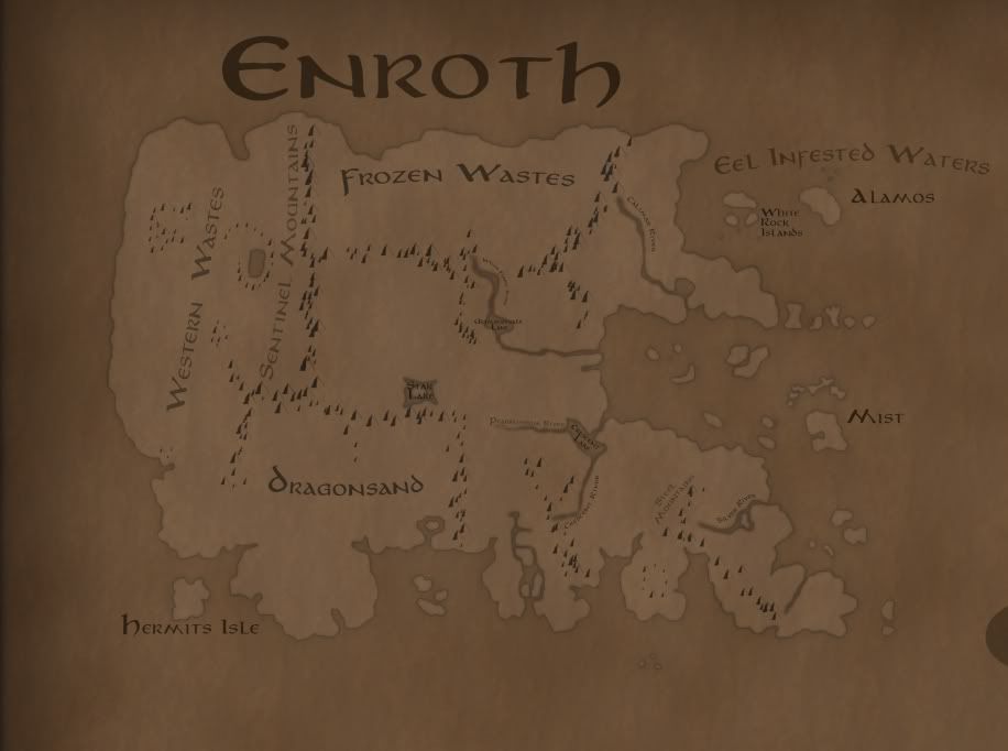
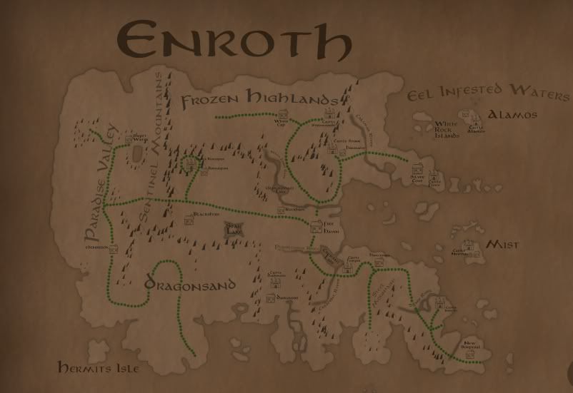
Map of World of Enroth (or C.O.L.O.N.Y.)

The role-playing games (I-X) that started it all and the various spin-offs (including Dark Messiah).
User avatar
Asomath
Pixie
Pixie
Posts: 107
Joined: 29 Apr 2011

Unread postby Asomath » 13 Dec 2011, 16:30

Yep Enroth is a pretty strange planet... there are other factors that play in besides typical earth-like climatology.

There will definently be multiple versions of each map, so people can pick or choose as they desire.

Does anyone know the name of the mountains that seperate Silver Cove from the Frozen Highlands?
Corlagon wrote:
- The White Forest River exists somewhere, but it's not really specified exactly where.
The only river left in Enroth that does not have a name claimed is the one that flows from the Frozen Highlands into Glimmervale Lake. It would actually fit as "White Forest"... when you go near the river there is as much of a "forest" as any in Might and Magic VI. These are pine trees covered with snow (in decent numbers) surrounding the river. It would make sense that this would be the "White Forest" and that the river would in fact be the White Forest River. Would anyone have objections if I marked it as such?


~Asomath

User avatar
overall
Pixie
Pixie
Posts: 125
Joined: 05 Feb 2010

Unread postby overall » 13 Dec 2011, 16:47

Asomath wrote:@overall, um, le what? XD
nothing special rely... watermelon cat just thinks that any of this pictures dosent still make any sense x)
i havent rely never point much tension this maps they dont seem to be so much planned... or in their time world was bit flat and squary, looks like enroths edge of the world is where A4 ending x)...
but sure i like to check this map when its done :)

User avatar
Corlagon
Archangel
Archangel
Posts: 1421
Joined: 03 Sep 2007
Location: HC/CH

Unread postby Corlagon » 13 Dec 2011, 17:23

Asomath wrote:It would make sense that this would be the "White Forest" and that the river would in fact be the White Forest River. Would anyone have objections if I marked it as such?
Makes perfect sense to me. :)

Some more detail on Carator from Heroes II:
Our enemy Archibald has begun to move troops into the mountainous mining regions of the south known as Carator, and we need to oppose him and seize these resources for ourselves. [...] In return for your aid, Rocklin has promised you the unconditional support of the dwarfs for as long as you should serve me. Already he has sent troops to the Carator mountains in anticipation of your move against Archibald.
Here are many of the named landmarks of Antagarich without any BS:

- Angel Gate
- Avauntnell
- Barrow Downs
- Battlestead
- Bracada Desert
- Bracada Highlands
- Bragden
- Brighton Point
- Cloverfield
- Deyja Moors
- Emerald Hills
- Ferris
- Fire Coast
- Forestbury
- Forestdale
- Forestdon
- Forestlow
- Frostland
- Frostpoint
- Gaia's Crest
- Grainrich
- Griffin Cliff
- Hillbridge
- Ironsand Desert
- Land of the Be-Warned
- Land of the Giants
- Marble Garden
- Marshland
- Minewell
- Moss Valley
- Motten Cliffs
- Mount Nighon
- Racken Cliffs
- Rionpoint
- Shandar River
- Shantanna
- Skyline Bay
- Strongwillow
- Teal River
- Thunderfist Mountain
- Tularean Forest
- Valley of Dagrond
- Wallpeaks
- Watershed Point
- Woodgrove
- Wyvern Plains

For Jadame there is unfortunately much less detail:

- Alvar River
- Shadowspire Mountains

I'll start making images specifying where each of these are. You can see many of them yourself if you have the Heroes III campaign editor. Otherwise, you probably know where a few of them are already.

User avatar
MMXAlamar
Hunter
Hunter
Posts: 541
Joined: 14 Jan 2011
Location: USA

Unread postby MMXAlamar » 13 Dec 2011, 20:16

Asomath, you'll probably want to read this and revise your map if you want a completely accurate one.
Tim Lang wrote:I wouldn't put too much stock in that picture [referring to the MM6 intro video]. That whole movie was made before JVC even created the Enroth map for MM6. As far as the Enroth map, we had a meeting on a friday where JVC said he was going to create a map over the weekend, and then came in on Monday with a map.
While the large continent looks especially like Enroth, it may be deceiving, because at the time that video was made, there was no true map of Enroth in existence. Jon would have probably modeled Enroth partially based on the MM6 intro vid for consistency, primarily that the "asteroid-ish" structure that crashed on the planet was in fact the Kreegan Hiveship landing in Sweet Water.

User avatar
Asomath
Pixie
Pixie
Posts: 107
Joined: 29 Apr 2011

Unread postby Asomath » 13 Dec 2011, 21:27

Revise it in what manner? Do you mean the left and top of Enroth?

~Asomath

User avatar
MMXAlamar
Hunter
Hunter
Posts: 541
Joined: 14 Jan 2011
Location: USA

Unread postby MMXAlamar » 13 Dec 2011, 21:42

Actually I was looking at the unknown island, but it looks good on the map to have a vacant island, so nvm!

User avatar
Asomath
Pixie
Pixie
Posts: 107
Joined: 29 Apr 2011

Unread postby Asomath » 13 Dec 2011, 22:01

Haha yeah. They kind of balance out the map a bit.

This is what the Continent of Enroth looks like at the moment (1/3rd real size)

Image

Im not sure as to where the Antagarich geography is located, so if you could get a picture that would be great.

After mountains woods and lakes, I'll be doing villages and Castles.

~Asomath

User avatar
Avonu
Round Table Hero
Round Table Hero
Posts: 3858
Joined: 06 Aug 2006
Location: City of Griffin
Contact:

Unread postby Avonu » 13 Dec 2011, 22:16

Frozen Wates - Frozen Highlands

Western Wastes - Paradise Valley (sometimes named Pleasent Valley) and Sweet Water. They weren't wastes before Night of the Shooting Stars.

User avatar
Asomath
Pixie
Pixie
Posts: 107
Joined: 29 Apr 2011

Unread postby Asomath » 13 Dec 2011, 22:29

Which is what im a little unsure of... should this map be pre MM6 or post?

~Asomath

User avatar
Asomath
Pixie
Pixie
Posts: 107
Joined: 29 Apr 2011

Unread postby Asomath » 14 Dec 2011, 02:42

I added Castles, Towns, and Roads. I put them all in groups,, so I can take pictures with some things hidden as desired. Todays progress in Enroth:

Image

~Asomath

User avatar
tolich
Raider
Raider
Posts: 753
Joined: 10 Jan 2009
Location: Minsk, Belarus

Unread postby tolich » 14 Dec 2011, 10:17

Corlagon‘s Estate? Tomb of VARN? Abdul's Resort?

User avatar
Asomath
Pixie
Pixie
Posts: 107
Joined: 29 Apr 2011

Unread postby Asomath » 14 Dec 2011, 11:32

Abdul's resort I forgot.

Varn and Corlagon's Estate arent so much Castles or Towns... more dungeons. Which I'll go back and do after I get Antagarich's and Jadame's basic marking done.

~Asomath

User avatar
MMXAlamar
Hunter
Hunter
Posts: 541
Joined: 14 Jan 2011
Location: USA

Unread postby MMXAlamar » 14 Dec 2011, 16:27

Those maps look superb, Asomath!

If your game is still set during the war of the Church of the Sun and Moon, this map would resemble the land after. So as Avonu said, you should change the name of Pleasant Valley.

I know that Corlagon has extensive knowledge of the lands beforeery MM6 occurred from when we were discussing the colonial government. He would be very helpful with the names of the towns/areas.

It would be very interesting if, in MMT's story, you involved hinting at a report of Kreegan forces in distant space, accelerating toward the planet. It could be via some Ancient intel. I don't know what your plans for Sheltem are, but you'll certainly want to match up your time periods. We have plans for Sheltem in MMX too, and it would be nice if we could coordinate them so both games are canonical as possible.

User avatar
GreatEmerald
CH Staff
CH Staff
Posts: 3330
Joined: 24 Jul 2009
Location: Netherlands

Unread postby GreatEmerald » 15 Dec 2011, 08:32

By the way, you might want to increase the contrast of those maps. Brown on brown is not the easiest to make out.

User avatar
Asomath
Pixie
Pixie
Posts: 107
Joined: 29 Apr 2011

Unread postby Asomath » 15 Dec 2011, 11:39

Yeah, I'm trying to work out decent colors while still maintaining the "old-timey" look.

@MMX this map isnt specifically for MMT, it's more directed just to getting a resource out to fans, that may assist in consolidating games to a more accurate representation.

User avatar
Slayer of Cliffracers
Hunter
Hunter
Posts: 549
Joined: 11 Jul 2006
Location: Gateshead, England.

Unread postby Slayer of Cliffracers » 15 Dec 2011, 14:10

GreatEmerald wrote:Even then, it would be pretty wacky, since it would imply that Antagarich is all in the temperate climate zone, so it should be pretty small indeed. That said, I don't recall ever seeing any jungles on Antagarich, either. The desert goes right to grasslands.

And yes, Slayer, cold currents do indeed exist :)
Funnily enough, it is all in the temperate climate zone, Av Lee is temperate and it's the northern part of Antagarich. If cold currents go north and warm currents go south (in the southern hemisphere) then it is pretty easy to figure out what's going on.

A current goes southwards and actually goes around the whole Antagarich continent. A cold current going north goes through Vori, the two currents meet around Tatalia which is why Tatalia is so wet.

Interestingly however, Tatalia must be a lot colder than one might imagine given the reptilian lifeforms found there. But reptiles can live in cold places and nowhere is it stated that Tatalia isn't cold in the winter.
Working on tracking the locations of Heroes IV battles. Stage 6 of campaign map finished, all initial Heroes IV campaigns mapped.

http://www.celestialheavens.com/forums/ ... hp?t=11973

User avatar
Secret_Holder
Assassin
Assassin
Posts: 266
Joined: 29 Oct 2006
Location: The freezing cold North

Unread postby Secret_Holder » 17 Dec 2011, 18:52

Interestingly however, Tatalia must be a lot colder than one might imagine given the reptilian lifeforms found there. But reptiles can live in cold places and nowhere is it stated that Tatalia isn't cold in the winter.
If i'm understanding you correctly, you're saying that Tatalia should be cold because reptiles live there?
This is not true, because reptiles are cold-blooded and would be terribly adapted to a cold, snowy climate.

User avatar
MMXAlamar
Hunter
Hunter
Posts: 541
Joined: 14 Jan 2011
Location: USA

Unread postby MMXAlamar » 17 Dec 2011, 22:48

Secret_Holder wrote:
Interestingly however, Tatalia must be a lot colder than one might imagine given the reptilian lifeforms found there. But reptiles can live in cold places and nowhere is it stated that Tatalia isn't cold in the winter.
If i'm understanding you correctly, you're saying that Tatalia should be cold because reptiles live there?
This is not true, because reptiles are cold-blooded and would be terribly adapted to a cold, snowy climate.
I've played MM7, Tatalia is half swamp and half snowy highlands.

vmxa
Leprechaun
Leprechaun
Posts: 39
Joined: 08 Nov 2011
Location: oviedo, fl

Unread postby vmxa » 18 Dec 2011, 14:26

What reptiles are in Tatalia? In MM7 there are trolls, one dragon in a cave and human forms. There are ghost in the island dungeon.

User avatar
Corlagon
Archangel
Archangel
Posts: 1421
Joined: 03 Sep 2007
Location: HC/CH

Unread postby Corlagon » 18 Dec 2011, 16:18

Not a Heroes 3 player, are you...


Return to “Might and Magic”

Who is online

Users browsing this forum: No registered users and 7 guests